Tema
Port
Recent news
Operation Pictures
[ngg src=”galleries” ids=”1″ display=”basic_imagebrowser”]
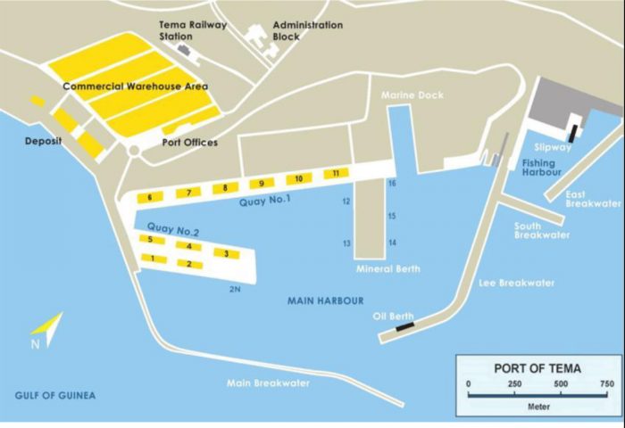
LOCATION
The Port of Tema is located 28 km east of Accra at 5°38’N and 0°01’E.
ARRIVAL
The port requires advance notice of 72 hours prior to the estimated time of arrival (ETA) – before 14.30 hours on Monday to Thursday and before 10.00 hours on Friday for weekend working.
ANCHORAGE
There is good anchorage between 1.5 km to 4 km ENE to SW off the main harbour entrance in depths of 9 metres to 18 metres with good holding ground. The Eastern area of the anchorage is most suitable without additional swell reflected from the main breakwater.
TOWAGE
Towage is compulsory within the harbour. The port authority operates four tugs: two of 1,866 kW, one of 1,860 kW and one of 1,644 kW. All tugs are fitted with pumps and monitors for firefighting.
APPROACH
Harbour entrance is 240 metres wide with a depth of 12.5 metres. A heavy swell may be encountered at 400 to 600 metres from harbour entrance during the monsoon season from April to September which causes vessels to roll heavily up to 40-80. For this reason, deep draught vessels enter only at high tide to obtain sufficient keel clearance.
RADIO
The port maintains a 24-hour watch on VHF Channels 14 and 16 and any other convenient channel. This signal station can reach vessels 140 km away. During harmattan conditions, vessels can hear the signal 400 km from port. The Port of Tema is linked with the Global Maritime Distress and Safety System (GMDSS).
WEATHER
Light to strong breezes from W and SW throughout the year except from December- February when the NE harmattan dominates, causing poor visibility. Dangerous winds are tornadoes from E during May-July. There is a swell in the harbour, especially after tornadoes which requires about 0.5 metres under the ship’s keel when lying alongside the wharves.
WORKING DAYS/HOLIDAYS
The port works a SSHINC system from 0700 hours to 1900 hours for the day shift and 1900hours to 0700hours for the night shift. But it is closed to public on Christmas day and good Friday.
TIDES
Tidal heights of 1.6 metres at MHWS and 1.3 metres at MLWS and 0.7 metres at MLWN are recorded twice daily.
Maximum safe depths and maximum length
Main port
| b/u | LOA (m) | Depth (m) * | Max permissible draught (m) |
|---|---|---|---|
| 1. Container | 299 | 11.2 | 11.2 |
| 2. Multipurpose | 275 | 11.4 | 11.4 |
| 3. Multipurpose | 228 | 10 | 10 |
| 4. Multipurpose | 181 | 9.4 | 9.2 |
| 5. Multipurpose | 183 | 8.8 | 8.5 |
| 6. Multipurpose | 183 | 8.3 | 8.2 |
| 7. Multipurpose | 183 | 7.5 | 7.5 |
| 8. Multipurpose | 183 | 8.2 | 8.2 |
| 9. Multipurpose | 183 | 8.4 | 8.2 |
| 10. Multipurpose | 183 | 8.4 | 88.2 |
| 11. Cement/Clinker | 183 | 8.4 | 8.2 |
| 12. Dry Bulk | 220 | 8 | 8 |
| 13. Dry Bulk | 220 | 8.2 | 8.2 |
| 14. Dry Bulk | 220 | 8.2 | 8.2 |
| 15. Dry Bulk | 220 | 8.2 | 8.2 |
| 16. Multipurpose | 100 | 8.2 | 8.2 |
| 17. Valco | 175 | 9.8 | 9.6 |
| 18. Oil | 244 | 10 | 9.6 |
Depth Of Water At Berth At Chart Datum
- Berths 1 strictly for container vessels
- Max. Length of V/LS to berths 1 & 2 = 265m
- Max. Draft of V/LS to berths 1 & 2 = 11.2m
- Spaces between bollards at Quay 1 are approx. 30m.
- Spaces between bollards at Quay 2 extension are generally variable.
- An underkeel clearance of 0.2m is allowed for.
- Other available berths are for bagged cargo vessels and others still with priority for Container vessels.
- Berth: Maximum Length of berths and corresponding Maximum Safe Depths at Chart Datum.
* Please be advised there are no Air, Loa and beam restrictions